


Contest 'Seize the beauty of our Planet' for the best satellite image of Earth
2025 edition: Cities and nature

'Seize the beauty of our Planet' contest 2025 winners
It is the 6th time that CloudFerro, a Copernicus Ambassador, has invited Earth observation specialists, climate researchers and enthusiasts to join the contest and turn satellite data into powerful messages. This year we were looking for best images on the theme of 'Cities and nature'. To join our contest, users needed to generate a satellite image of their chosen location and submit it to us on a dedicated webpage. The image could be generated on any platform with Copernicus Earth observation data, such as CREODIAS, Copernicus Data Space Ecosystem, WEkEO, CODE-DE or EO-Lab.
The winners were selected by internet users, who voted for the best 13 images, and then a Jury, who chose the top three entries that took the 1st, 2nd and 3rd place.
The Jury was composed of Simonetta Cheli, the European Space Agency (ESA), Lothar Wolf, the European Organisation for the Exploitation of Meteorological Satellites (EUMETSAT), dr. Marta Wachowicz, the Polish Space Agency (POLSA), Emmanuel Pajot, the European Association of Remote Sensing Companies (EARSC), prof. Katarzyna Dąbrowska - Zielińska, the Polish Institute of Geodesy and Cartography (IGiK), and dr. Jędrzej S. Bojanowski, CloudFerro.
As the voting phase has come to an end, we can finally announce the winners.
Please note: the descriptions of the images are provided by the authors.
Meet the winners!
1st place
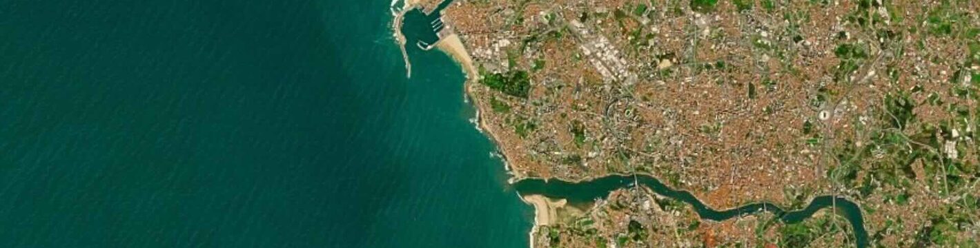
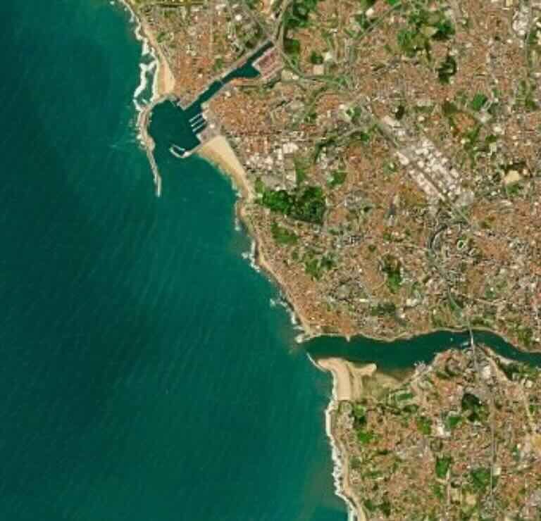
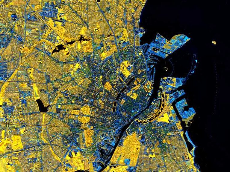
Copenhagen’s Golden Veins of Urban Life: A Model for Climate-Ready Cities
by Lukumon Lateef from Portugal
This Sentinel-2 image of Copenhagen, Denmark, home to about 1.4 million urban residents, shows how green life weaves through one of Europe’s most liveable capitals. The image composite, created from the infrared and blue bands, highlights vegetation in vibrant golden/ yellow tones, depicting the city’s extensive network of parks, street trees, and other urban vegetation. This stands out against the light blue patterns of urban structures (buildings, roads, and rail corridors) and the deep blue of surrounding waters, including Copenhagen Harbor and surrounding channels. The image captures the balance between a thriving urban area and its green infrastructure, which demonstrates how urban design and nature can coexist. The Sentinel-2 image (Level 2A) was acquired on 24 September 2025.
Modified Copernicus Sentinel-2 data (2025)
2nd place
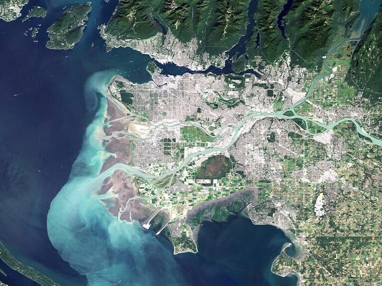
Vancouver – Harmony of People and Nature
by Kamil Onoszko from Poland
Vancouver is a Canadian city where urban life coexists in harmony with nature. Its innovative urban planning prioritizes the creation of abundant green spaces and parks, further strengthening this balance. The satellite image highlights the interplay between the city, river, ocean, and surrounding mountains, showcasing a landscape that promotes well-being and a high quality of life.
Contains modified Copernicus Sentinel data (2025-08-22)
3rd place
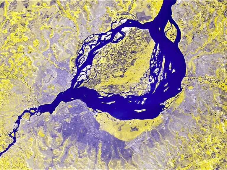
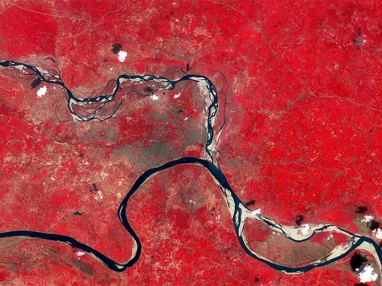
Just A River Apart
by Ankur Negi from India
Nature often dictates man’s boundaries. From a bird’s-eye view, the political boundaries between the two capitals in two countries disappear - only the natural meandering of the Congo River represents the separation. To the south of the river lies Kinshasa, the capital city of the Democratic Republic of Congo; to the North lies Brazzaville, the capital city of Congo. This image has been developed using satellite imagery from Sentinel-2 dated 19 August 2025. The visualization has been created using bands (B4, B4, B3).
Modified Copernicus Sentinel-2 data (2025)
Other winners:
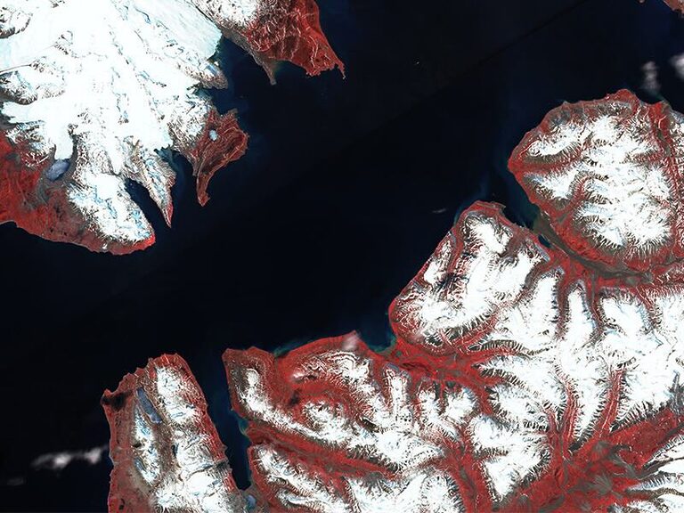
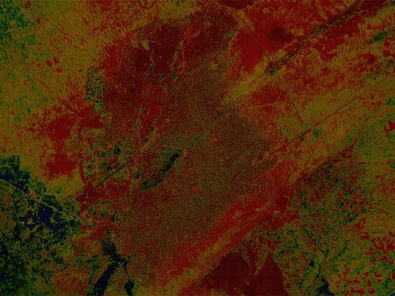
Svalbard - Longyearbyen - the fastest-warming town on Earth
by Maciej Frankiewicz from Poland
Longyearbyen, the fastest-warming town on Earth, a once completely snow-covered town, is now getting warmer and warmer every day, with the snow and ice surrounding the place melting because of climate change. You can clearly see Longyearbyen’s airport in the center of the image and Longyearbyen itself right next to it. The image is shown in the false color composition, the red color represents plant-covered land. Image taken by Sentinel-2, 2024-06-29.
Modified Copernicus Sentinel-2 data (2024)
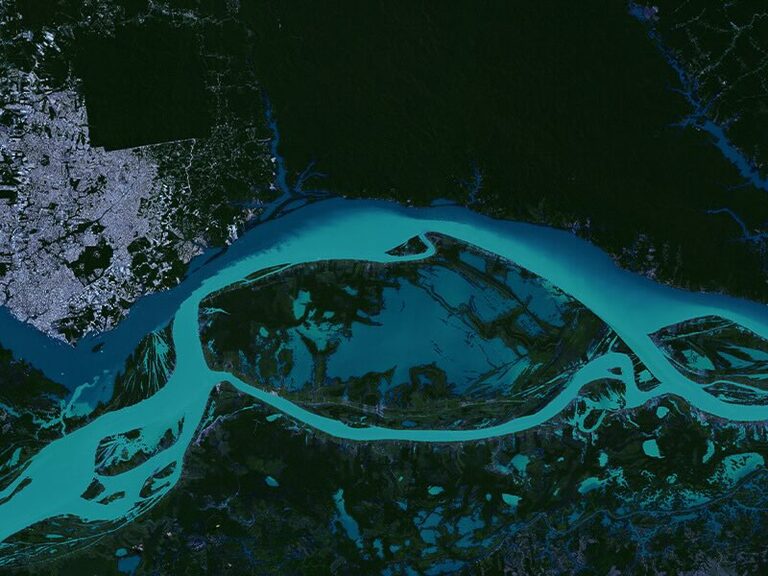
The Genesis Of The Great Amazon River - The Meeting of Waters in Manaus - Brazil
by André Vilela from Brazil
This Sentinel-2 image, captured on 24 August 2025, showcases the iconic Meeting of the Waters in Manaus (AM), where the dark waters of the Rio Negro and the sandy green waters of the Solimões River flow side by side for over 6 kilometers without mixing. This spectacular phenomenon marks the formation of the Amazon River, the world’s largest river by volume, and highlights Manaus as a city uniquely positioned at the intersection of urban development and one of the planet’s most dynamic ecosystems. The striking contrast between the rivers results from their distinct origins and properties: the Rio Negro carries acidic, organic-rich water from the rainforest, while the Solimões River, originating in the Peruvian Andes, transports mineral sediments. Differences in temperature (28°C vs. 22°C), density, and flow velocity prevent immediate mixing, creating a visually dramatic boundary observable even from space. The image was processed in True Color (bands 4, 3, 2) and enhanced with the NDWI (Normalized Difference Water Index), calculated as (B3–B8) / (B3+B8), using an inverted Deep Sea gradient to emphasize the separation between the rivers and the surrounding urban landscape. This visualization illustrates the intricate hydrological dynamics of the central Amazon, demonstrating how cities and nature coexist in one of the planet’s most extraordinary environments.
Modified Copernicus Sentinel-2 data (2025)
Allahabad - Problem with water in a large city
by Amelia Kubieniec from Poland
It’s a large city with a population of about one million. Its problem is water shortage. The city is surrounded by two rivers: the Ganges and the Yamuna. The Ganges River is heavily polluted. This image was taken by the satellite Sentinel-2, L1C, band „false color”. 2015-10-02.
Modified Copernicus Sentinel-2 data (2015)
The Contradictions of the COP 30 City - Belém, Pará, in the Brazilian Amazon, where urban growth, rivers, and the world’s most biodiverse forest meet
by Giulia Silveira from Brazil
Belém, the host city of COP 30, is a place of striking contrasts. In this view, the dense Amazon rainforest meets the sprawling urban area and surrounding waterways. This juxtaposition of thriving nature, expanding urbanization, and vital water systems reflects the contradictions of a city preparing to welcome the world to a global climate summit. This image highlights the urgent challenge of balancing urban growth with the preservation of the Amazon, the most biodiverse forest in the world. Location: Belém, Pará, Northern Brazil. Satellite/Data: Sentinel-2, false color composite. Date of observation: 12 August 2025.
Modified Copernicus Sentinel-2 data (2025)
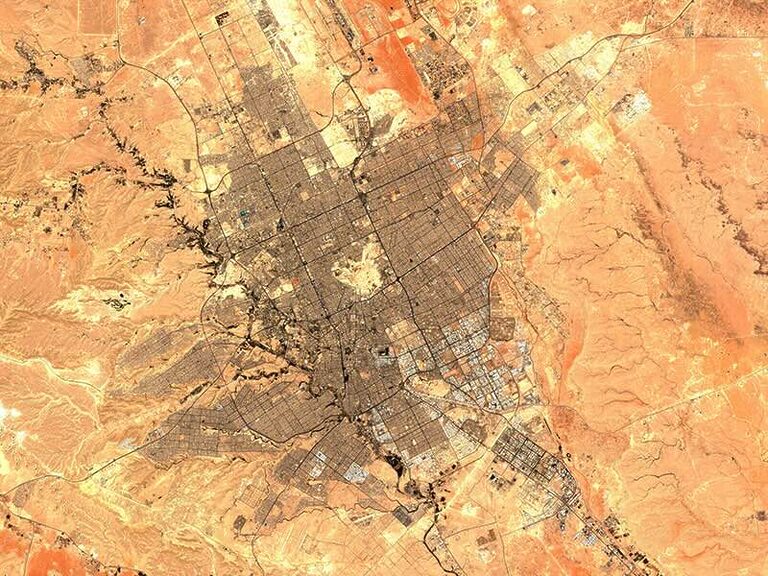
Riyadh - the capital of Saudi Arabia - The city in the middle of the desert
by Kamil Kamiński from Poland
The image shows the city of Riyadh in the middle of the Ad-Dahna Desert in Saudi Arabia. I chose this location because it shows the difference between the desert sands and the city. Orange shades indicate the desert areas, while brown shades indicate urban development. The image also clearly shows the street grid. The image was taken in the NDSI layer on October 23, 2025, by the Sentinel-2 satellite with its L2A array.
Modified Copernicus Sentinel-2 data (2025)
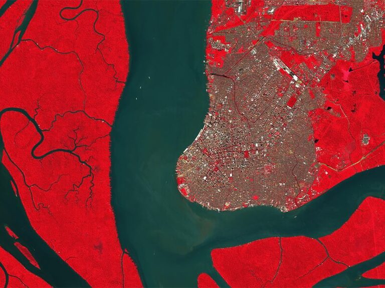
The Metro Breathes into the Bay
by James Rommel Silao from Philippines
This false-color image captures Metro Manila discharging wastewater and urban runoff into Manila Bay through the Pasig River. While this occurrence is common, it remains an alarming indicator that reflects the continuing challenge of managing waste and wastewater disposal in a highly urbanized city like Metro Manila. Ironically, the remaining green spaces in the city (bright-red patches) are golf courses, highlighting the uneven distribution of recreational land among the populace. Just below the plume’s exit, a striking gray feature stands out - artificial islands being constructed as part of a reclamation project aimed at expanding the metro in the face of limited space, but also raises ecological concerns to marine habitats and coastal ecosystems. The metro breathes stronger, but the bay holds its breath.
Modified Copernicus Sentinel-2 data (August 4, 2025)
Al-Fashir - Sudan - The Forgotten War
by Ola Elwasila Abelrahman Yousif from Sudan
In Al-Fashir, Sudan, fires from a conflict now lasting over two years have devastated large parts of the city. The red tones mark burned areas detected by NBR analysis over a natural RGB composite, showing the full extent of urban destruction. This Sentinel-2 image captures the city’s transformation from space, where the scars of war remain clearly visible — a stark reminder of the human cost across Darfur.
Modified Copernicus Sentinel-2 data (2025)
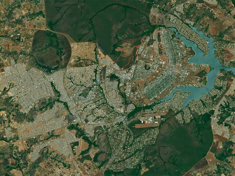
Brasília’s Unplanned Sprawl - Brazil
by Frederico Ramos from the Netherlands
Brasília, the purpose-built capital of Brazil, stands as one of the most significant experiments in modernist urban planning. Inaugurated in 1960, the city was designed by Lúcio Costa and Oscar Niemeyer. Its core design, known as the Plano Piloto (Pilot Plan), famously resembles an airplane or a bird in flight. The dream of a perfectly controlled, modernist metropolis, however, quickly clashed with the realities of rapid national development and mass migration. The city’s population growth far exceeded its initial capacity in a remarkably short time, reaching the planned limit by 1970. Today, the metropolitan area of Brasília, encompassing the Federal District and surrounding municipalities, is home to approximately 4.8 to 5 million people, a figure nearly ten times the original planned population for the Pilot Plan.
Modified Copernicus Sentinel-2 data (2025)
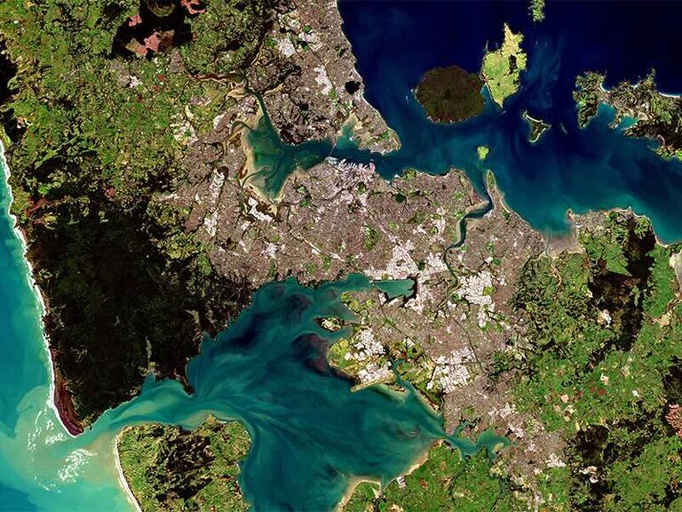
Auckland - A City Between Sea and Volcanoes
by Martyna Sosnowska from Poland
This satellite image shows Auckland – the largest city in New Zealand, situated on a narrow isthmus between the Tasman Sea and the Pacific Ocean. From space, the city’s unique relationship with nature is evident: dense urban areas blend with bays, green volcanic hills, and coastlines shaped by ancient eruptions. Auckland has grown in close connection with its natural surroundings, with waters, forests, and farmlands shaping its borders. It is among the world’s leading cities in sustainability efforts, investing in renewable energy, low-emission transport, and biodiversity protection. Auckland serves as a vivid reminder that coexistence between people and nature is possible when cities respect their natural environment.
Modified Copernicus Sentinel-2 data (August 20, 2025)
Congratulations to all the winners, and thank you for joining our contest!
What are the goals of the contest
Compelling images capture public and policy attention. This year, we invited EO specialists to seize satellite-derived view of an urban area of their choice to help tell a story that matters for the planet because the imagery can galvanize communities and policymakers to plan cities that thrive with nature and serve the people who live in them.
The main goals of the contest are:
Join forces to protect our Planet, in this year's edition we are focused on cities – we want to support the joint efforts of many European, international and regional organisations in promoting sustainable growth of urban areas, with respect for the natural environment.
Educate about the irreversible effects of climate change, in particular regarding urban areas - let's bring the attention of decision-makers and communities to the challenges of today's cities and the needs of their inhabitants.
Promote Copernicus Programme - as a Copernicus Ambassador, CloudFerro aims to highlight the the key role that the Copernicus Earth observation data plays not only in environmental research but also in effective and cost-efficient urban planning and monitoring.
Contest schedule
02 October - 26 October - Collecting contest entries
30 Oct - 11 Nov - Phase 1 - public voting to select 12 finalists with the highest number of votes
12 Nov - 17 Nov - Phase 2 - Jury voting for 3 top entries out of the 12 chosen in the public voting
19 Nov - Winners announcement
How are the winners selected and what are the prizes?
12 images with the highest number of votes will be the finalists and will proceed to the 2nd phase, in which a Jury consisting of EO experts will vote for the best 3. The authors of the 3 images with the highest number of the Jury votes will be awarded the following prizes:
- Apple iPad 10,9" 64GB - 1st place
- Apple Watch SE 2nd gen. - 2nd place
- Apple AirPods 4 ANC - 3rd place
The authors of all the entries accepted for the 1st phase of the contest will be awarded a CloudFerro calendar for 2026 composed of the winning images.
What were the image requirements
- The satellite image submitted to the contest should depict an urban area.
- The image needed to be obtained on an Earth observation platform (such as CREODIAS, Copernicus Data Space Ecosystem, WEkEO, CODE-DE or EO-Lab) by means of tools available on these platforms.
- The satellite data could be visualized in a dedicated software of the user's choice (e.g. QGIS) to highlight the phenomena you wish to show. We prepared a tutorial on how to create an image for the contest.
- The image had to meet a minimum requirement of 250 dpi, 6500 x 5000 pixels, but less than 8000 px.
- Each contest entry had to be described with details such as: name of the place, location, name of the satellite that generated the image/data you used, the date of the satellite observation. Please add your motivation for choosing this particular place/city.
- Only ONE image could be submitted by each contestant.
- The image could be enhanced with Earth observation or photo editing software but it could NOT contain any text or additional graphic elements such as labels, logos or similar.
Where users could generate the contest image
In the contest, we are looking for the best satellite images depicting an urban area. The images could be generated on an Earth observation platforms with Copernicus programme data, such as:
- CREODIAS - a European Copernicus DIAS platform, commissioned by European Space Agency, that combines public cloud computing, access to a satellite image repository, and a range of applications that allow users to search, view, and process satellite products. It is the first commercial element of the Copernicus Data Space Ecosystem.
- Copernicus Data Space Ecosystem - launched in January 2023, it is the largest EO data offering in the world and the main EO data dissemination endpoint of the European Space Agency (ESA), with outstanding discovery and download capabilities, and a set of data processing tools. It is built by a consortium of European cloud and Earth observation service providers: T-Systems, CloudFerro, Sinergise, VITO, DLR, ACRI-ST, and RHEA.
- WEkEO - another European Copernicus DIAS jointly implemented by EUMETSAT, ECMWF, EEA and MERCATOR OCEAN. It provides combined access to environmental data and information from the Copernicus Sentinels and the Copernicus Monitoring Services, together with virtual environment for data processing and skilled user support.
- CODE-DE - a German national platform for authorities and other public institutions commissioned by DLR that provides easy and efficient access to all Copernicus remote sensing data about Germany, a virtual secure working environment for processing these data and extensive information materials and trainings to support the users.
- EO-Lab - a German platform commissioned by DLR, providing a development environment for researchers from both scientific and commercial entities, which draws upon new cloud technologies and artificial intelligence (AI) to analyse a big amount of Earth Observation data.
- other Copernicus platforms.
Why the theme of Cities and nature?
Urban development poses significant environmental challenges as cities around the world expand to accommodate an increasingly urbanized population, which is expected to reach 68% by 2050 in the world, and 83.7 % in Europe. As cities continue to evolve, understanding the dynamics of urban growth and its environmental implications is crucial for fostering inclusive, resilient, and sustainable urban futures that benefit both our communities and the planet. [1] [2] [3]
This rapid urbanization not only drives economic growth – contributing approx. 80% of global GDP – but also exacerbates environmental issues, such as habitat loss, pollution, and increased greenhouse gas emissions, which currently account for about 75% of global emissions. The intricate balance between urban growth and environmental sustainability has made it a critical area of concern for urban planners, policymakers, and environmentalists alike. [4] [5]
Monitoring urban environments from space has become increasingly important. Remote sensing technologies and Geographic Information Systems (GIS) provide valuable data that can inform sustainable urban planning by enabling assessments of land use, air quality, and the impacts of development on local ecosystems. Earth observation is a backbone of crisis management and risk assessment. [6] [7]
That's why, this year we encourage participants of the contest to share an image that reveals how cities and nature can thrive together, or one that can spotlight today's urban challenges. This can help the public see what’s at stake and motivate leaders to act for greener, safer and resilient urban futures.
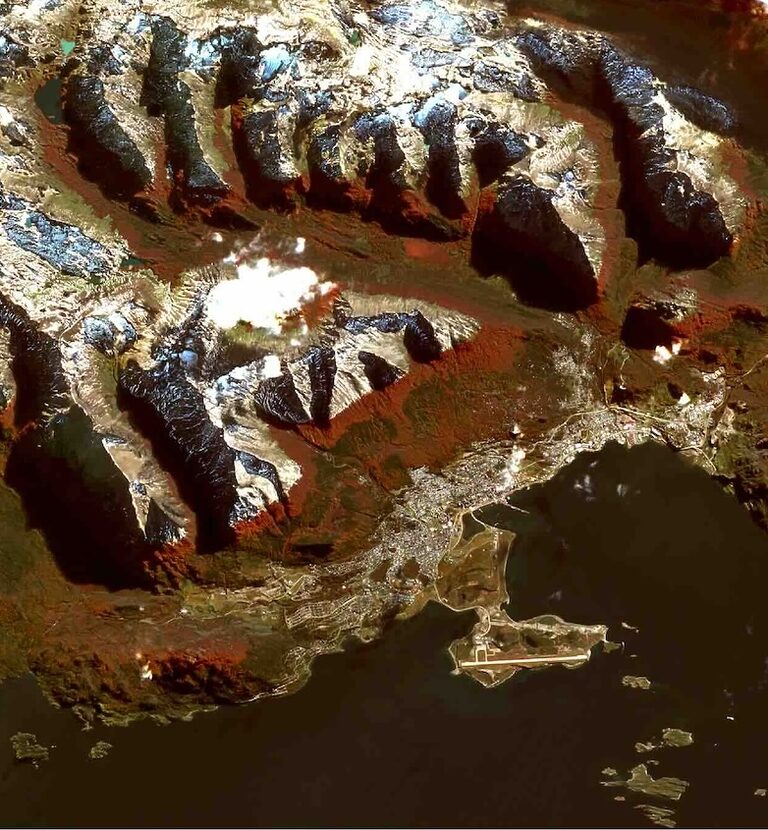
Ushuaia, Argentina, the world's southernmost city, situated between the Beagle Channel and the Martial Mountain range in the southern Argentine. Contains Copernicus Sentinel-2 modified data (7 April, 2025).. Contains Copernicus Sentinel-2 modified data (2025).
About the Copernicus data
Satellite observations play a key role in efficient and cost effective monitoring of the Earth ecosystems, and remote sensing techniques prove highly beneficial in this area. The European Copernicus Earth Observation programme provides data that has many attributes, spectral and spatial ones, about oceans, lands and atmosphere. They provide us with resources for environmental analysis in all dimensions, from local to global and from visible to radar techniques.
Scientists have developed various indices like NDVI, NDWI, and SMI, which are essential tools for Earth observation. NDVI measures vegetation health by comparing near-infrared (NIR) and red visible light wavelengths. NDWI, or Normalized Water Index, indicates water body extent and reflects biomass water content, commonly used in water management. The Soil Moisture Index (SMI) estimates soil moisture content using Sentinel-1 radar data. Additionally, SWIR or NIR data can help assess land dryness, vegetation coverage, and map extreme events like wildfires or flash floods.
By organising the contest we want to promote the use of satellite imagery that is a vital tool for understanding processes taking place on Earth on a larger scale, offering global coverage and instant access to accurate data.
Please contact us at communications [at] cloudferro.com for any questions that you may have. We will be happy to help you.
The details of the contest can be found here: Terms and Conditions (PDF).