Contest 2022 for best satellite image of Earth
Contest for the best satellite image in the "Seize the beauty of our Planet"
Together for Blue Earth!

3rd edition of the contest "Seize the beauty of our planet" Together for Blue Earth!
Winners of the 3rd ed. of 'Seize the beauty of our planet' contest announced!
Welcome to the page of the 3rd edition of the contest “Seize the beauty of our planet” for the best satellite image of the Earth, organised by CloudFerro. This edition focuses on WATER. That is why, the contest motto is: Together for blue Earth!
It is the third time we have invited the users of our EO platforms to join this competition. This year we were looking for the most outstanding imagery depicting water impacted by climate change or human action. The images were generated on CREODIAS, WEkEO, CODE-DE or EO-Lab- the platforms developed and operated by CloudFerro. The winners were selected by internet users, who voted for the best 13 images, and then a Jury, who chose 4 best images that took the 1st, 2nd and 3rd place. As the voting phase has come to an end, we can finally annouce the winners.
Meet the winners!
The winners of the 3rd edition of the contest 'Seize the beauty of our Planet' for the best satellite image of water on Earth are:
1st place
'Greenland - Tiniteqilaaq' by Emanuele Capizzi from Italy
The effect of climate change is visible on Greenland's ice, which is melting faster and faster. The image is taken by Copernicus Sentinel-2 on September 22, 2022 - North of Tiniteqilaaq.


2nd place
'Salt Lake of Life' by Boyan-Nikola Zafirov from Bulgaria
Atanasovsko lake is a coastal lagoon to the south and estuary to the north. The area has unique flora and hosts hundreds of migrating bird species taking the route of Via Pontica. The lake is at risk, threatened by pollution, fresh water floods and climate change. Image by Copernicus Sentinel 2, July 2022.
3rd place
3rd place - two images ex-equo:
'The moment of rain water reaching the sea in Antalya' by Enes from Turkey
The magnificent view where the alluviums carried by the rain water, reach the Mediterranean from many branches in Antalya. Just below the Antalya airport, there is the unique Düden waterfall pouring into the sea from a height of 40 meters. Copernicus Sentinel-2 5.2.2022.

'Great Barrier Reef Bleaching' by Michał Mirończuk from Poland
Global warming is strongly contributing to rising oceans temperature. The enviroment becomes too hot for the corals to survive causing them to bleach and eventually - die. The photo was captured by Copernicus Sentinel-2 satellite on 23/10/2022.

The above four images were chosen by a Jury composed of:
- Dr. Peter Albert, WEkEO Service Coordinator, EUMETSAT
- Simonetta Cheli, Director of Earth Observation Programmes and Head of ESRIN, European Space Agency (ESA)
- Agnieszka Gapys, Spokeswoman, Polish Space Agency (Polsa)
- Justyna Redelkiewicz, Head of Section Environment & Entrepreneurship, Market and Downstream Innovation, EUSPA
- Dr Michael Schmidt, Space Administration Project Manager at German Aerospace Center (DLR)
- Dr. Peter Wagner, Project Manager at German Aerospace Center (DLR),
- Dr. Jędrzej Bojanowski, Data Science Manager, CloudFerro.
The contest winners were anounced at a live event held online on Thursday November 17, 2022.
Other winners:

'Laguna Madre - hypersaline lagoon' by Adam Manista from Poland
The Laguna Madre is located along the Gulf of Mexico and separated from it by a number of islands. That causes the lagoon is 3 times saltier than the ocean. The reasons of sality are two: a high rate of evaporation due to its shallowness, and dry climate (Copernicus Sentinel-2, 2022/08/19).
'Tagus River Estuary Nature Reserve' by Maria Joao Costa from Portugal
Sediment and nutrient transport from Tagus Estuary to the Atlantic Ocean, flanked by Lisbon Metropolitan area with a population of 2.9 million people. Droughts and heatwaves are among the extreme events endangering the system. Agriculture affected is visible to the northeast. Copernicus Sentinel-2, 2022.


'Red River Flood' by Kamil from Poland
The Red River Valley in Manitoba, Canada - the largest flood in a decade [2022-05-05]. Contains modified Copernicus Sentinel data [2022].
'Balkhash - Sentinel-2' by Marek Gryboś from Poland
Asia's third largest lake, is drying up as water levels continue to decline in its main tributary, the Ila River in China. As it flows through the western reaches of China, with a rapidly growing human population, the river is losing water resources used in agriculture and industry. Copernicus Sentinel data (2020).


'Vanishing' by Maciek Myśliwiec from Poland
The dry riverbeds feeding Lake Powell resemble the preserved structures of plants trapped in stone millions of years ago. Image acquired by the Copernicus Sentinel-2 satellite on 19/10/2022.
'The behavior of Blue Dragon' by Emanuel Castanho from Portugal
Copernicus Sentinel-2 (2022) image obtained with Finder Tool and processed in SNAP. Calculation of Normalised Difference Water Index for two images, April 14 (blue tones) and October 13 (red tones), to isolate the Odeleite dam (Algarve, Portugal), whose reservoir resembles the shape of a dragon.


'Streak As Verdict of Earth Rivers - SAVER' by Chancy Shah from India
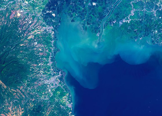
The Gulf of Khambhat lies on the west coast of India. The monsoon season from June to September increases heavy sediment loads discharged by seven major rivers. As freshwater begins to disperse and sink at the outer reaches of the gulf and the sediment appears in the satellite image. Copernicus Sentinel-2 data (2021).
'Pampanga River Pollution' by Ross from India
This satellite image depicts the impact on the sea and aquatic life, due to pollution in the Pampanga River (Philippines). We all should make a notion of saving the ocean. Satellite Name: Copercnisu Sentinel-2 ; Image Captured on 2019-02-17.


'Blue Earth Venice' by Mateusz Pietrzak from Poland
Venice, Italy Sentinel 2, 01.08.2022
Congratulations to all the winners, and thank you all who joined our contest!
To see all the contest images, click the button below.

What is the 'Seize the beauty of our Planet' contest about?
What is the contest about?
At CloudFerro, we believe that everyone should be aware of what is happening to our water environment in order to take care of it. The goal of the contest is to support the joint effort of many European and international organisations in protecting water - a valuable resource of our planet. Water protection is addressed in the EU’s Green Deal policy. In particular, Biodiversity Strategy for 2030 adopted by the Commission in May 2020 includes many initiatives for the marine ecosystems and surface water management that we wish to support with our contest.
In the contest, we are looking for the best satellite images depicting an area of ocean/deep seas or surface water or their surroundings that have been in any way affected by climate change or human impact. The images shoud be generated on one the platforms CloudFerro developed and operate:
- CREODIAS - a European Copernicus DIAS platform commissioned by ESA that combines public cloud computing, access to a satellite image repository, and a range of applications that allow users to search, view, and process satellite products.
- WEkEO - another European Copernicus DIAS jointly implemented by EUMETSAT, ECMWF, EEA and MERCATOR OCEAN. It provides combined access to environmental data and information from the Copernicus Sentinels and the Copernicus Monitoring Services, together with virtual environment for data processing and skilled user support.
- CODE-DE - a German national platform for authorities and other public institutions commissioned by DLR that provides easy and efficient access to all Copernicus remote sensing data about Germany, a virtual secure working environment for processing these data and extensive information materials and trainings to support the users.
- EO-Lab - a German platform commissioned by DLR, providing a development environment for researchers from both scientific and commercial entities, which draws upon new cloud technologies and artificial intelligence (AI) to analyse a big amount of Earth Observation data.
The best 13 images chosen in public voting (1st phase) and by a Jury (2nd phase) will be presented in CloudFerro calendar for 2023 that will be distributed among leading institutions, companies and organisations in the Earth Observation sector. The calendar will also be awarded to all the contest winners and participants whose images were admitted to the voting phase.
See the winning images of 2021 contest and 2020 contest.
Why water?
Water benefits all the living organisms on our planet and is vital for many sectors of the economy, agriculture, transportation, tourism, energy, climate dynamics, cultural heritage, and more. Water is our blue treasure that needs special protection and planning for its sustainable use to preserve it for the next generations.
Let's act together to raise the awareness of the need to protect water ecosystems and tackle today’s challenges such as water pollution, droughts, river regulations, floods, water level rise, and many more.
Satellite observations play a key role in efficient and cost effective monitoring of water resources, and remote sensing techniques prove highly beneficial in this area. The European Copernicus Earth Observation programme provides data that has many attributes, spectral and spatial ones, about oceans, seas, coastal areas, mangroves and any other water bodies. They provide us with resources for water analysis in all dimensions, from local to global and from visible to radar techniques.

Sentinel-3 OLCI RGB composition of bands 3, 12 and 6 respectively for 442.5, 753.75 and 560 nm of algal bloom, which occurred in June and July 2019 in Yellow Sea
The contest requirements
To join the contest, users needed to generate an image on one of the platforms developed and operated by CloudFerro – CREODIAS, WEkEO, CODE-DE, EO-Lab. The image should depict water pollution, droughts, regulated rivers, floods, water level rise or any other water area impacted by environmental or human change. We asked that the images should be obtained on CREODIAS, WEkEO, CODE-DE and EO-Lab platform by means of tools available on these platforms (on CREODIAS, CODE-DE and EO-Lab - choose: Finder tool, on WEkEO choose: Explore data) and visualized in a dedicated software of your choice.
To help users generate the image, we prepared a short online workshop where in just 1 hour our experts explain it step by step. We have also provided a video tutorial How to download EO data using EO Finder at CREODIAS and visualise it in QGIS.
Selection process and prizes
In the 1st stage starting on November 2, all the submitted images were put to an online voting of the general public. 13 images with the highest number of votes proceeded to the 2nd stage, in which the Jury consisting of the representatives of CloudFerro and its business partners vote for the best 3 images. The authors of the 3 images with highest number of Jury votes were awarded attractive prizes:
- a high quality tablet - Apple iPad 10.2 inch (Wi-Fi, 64GB) - 1st place
- a sport camera - GoPro HERO7 CHDHB-601-RW 4K UHD - 2nd place
- LARQ bottle with a self cleaning system using UV-C Light - 3rd place
The authors of all the entries accepted for the 1st phase of the contest are awarded a CloudFerro calendar for 2023 composed of the winning images.
Image quality and other requirements:
Apart from the esthetical aspects and the relation to climate change, the image must meet a minimum requirement of 250 dpi, 4200 x 3000 pixels or more. Only ONE image could be submitted by each contestant. The image could be enhanced with EO or photo editing software but it must NOT contain any text or additional graphic elements such as labels, logos or similar.
Where will the images be used?
The images that meet the requirements of the competition will be used in CloudFerro communication to promote the Copernicus programme and the European values, and they will be published in online and print communication materials. The 13 winning images will also be published in a calendar for 2023 prepared by CloudFerro.


